| The relational database | < Connecting geo-information with the database > | Filing system |
The complex format of GIS data requires that map files ("geodata") are stored outside the database, while metadata on maps and filenames are administered within the GROMS database (see Figure 3.3). The innovative aspect of GROMS is its efficient integration of the different modules, and in particular of geodata.
Transformation of printed maps into GIS format requires
The rather technical details of these processes are described in more detail in Annex I, while the following section gives an outline of basic principles and caveats for the novice.
Most maps describe the general distribution ("Expected Area") of a species' range, which might differ from the actual distribution ("Area of occupancy"), which is based on well-documented point data or well-defined distribution models (Figure A2.13; for a detailed discussion, see Institute of Applied Ecology 1998). In addition, most maps are on a global scale, and users should bear in mind that accuracy is in the range of ± 100 km. Additional, minor errors occur by transformation into the GIS-format. Maps have been adopted from the source without modification. Therefore, the bibliographic reference is an integral part of the map. For some species, GROMS contains maps from different sources, at various resolutions, and they reveal considerable differences when superimposed (see Figure A2.17: Monachus monachus, Figure A2.49: Vanellus gregarius, and chapter 4.3).
Additional point data have been gathered from "observation points", which are simply defined by their geographic place name and co-ordinates (latitude and longitude).
Such places can be aggregation sites for breeding, staging or moulting, monitoring sites such as bird observatories, or even catastrophic events such as oil spills or red tides. By linking observation points with the species table, GROMS encompasses all these possibilities within one common underlying data model. Point co-ordinates are stored directly within the database, but can easily be integrated into the respective GIS maps (see Figures A2.28 ff.). As a test for database structure, functionality and retrieval tools, 850 important staging areas for Eurasian ducks have been entered from Scott & Rose (1996). This data set allowed calculation and mapping of species diversity for each site (Figure A2.39).
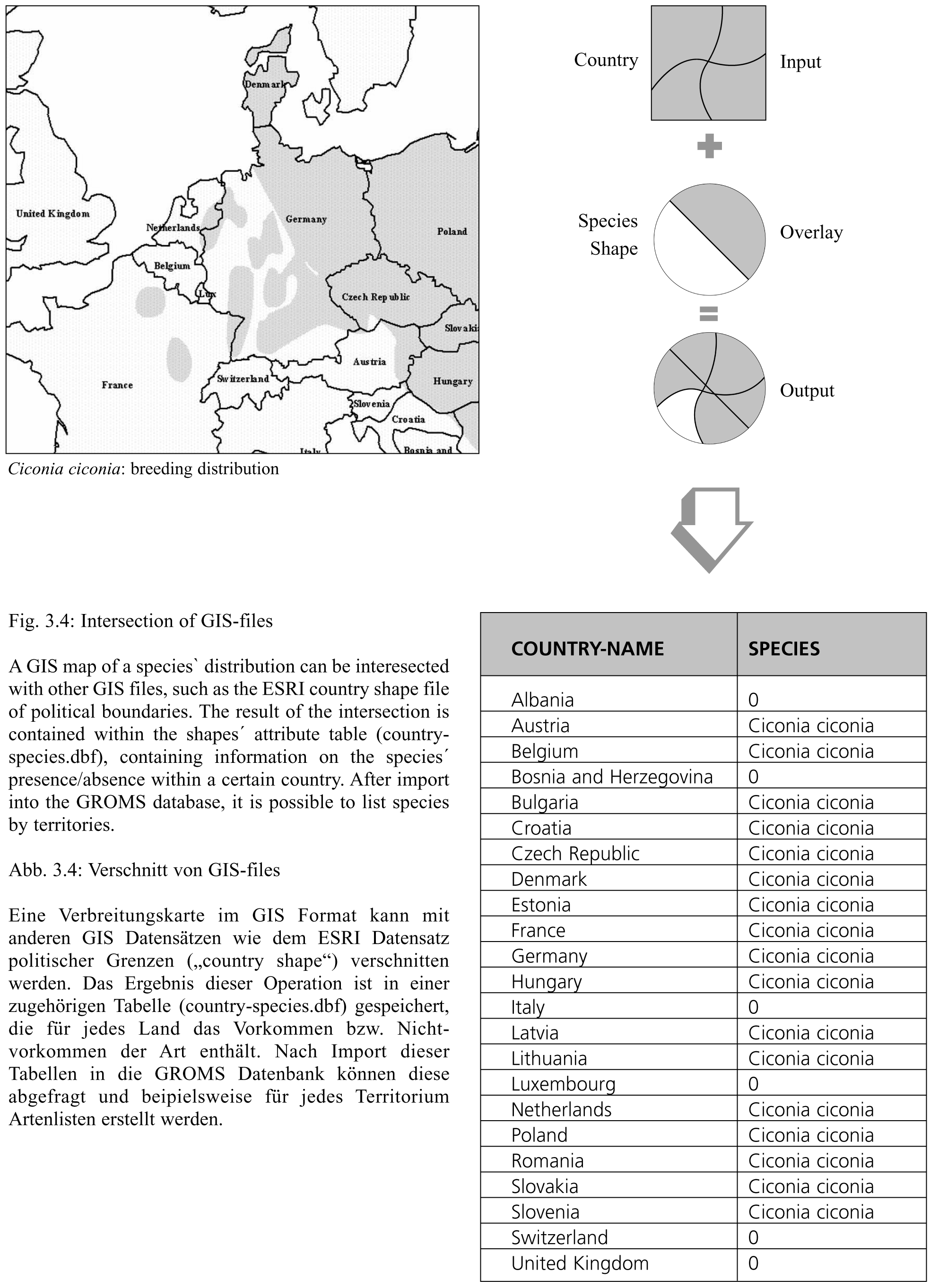
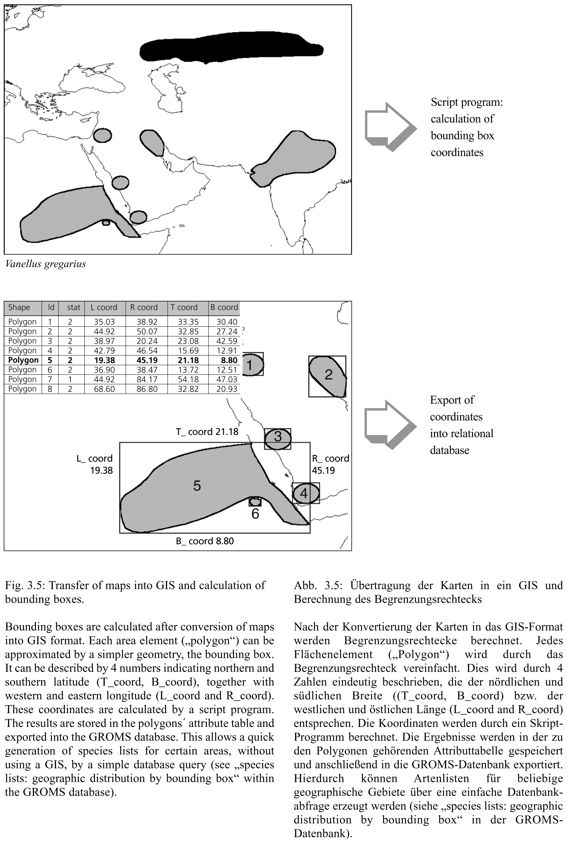
Most GIS analysis has to be performed with GIS software, i.e. outside the database. However, even the simple question for species occurring within a certain area requires the execution of a number of complex GIS operations. Therefore, some results of general interest have been integrated into the database. The two examples illustrated in Figures 3.4 and 3.5 generate information on the range states and provinces, where a species is reported, and the bounding boxes for each distribution area (Figure 3.5). The results have been stored in the relational database, and therefore allow a much more efficient retrieval of geodata, without using the GIS.
Figure 3.4 illustrates an example of integrating geo-data resulting from GIS operations into the database: species distribution maps were intersected with geopolitical units, and the resulting lists of territories is then integrated into the database. A second example is illustrated in Figure 3.5, showing the calculation of bounding boxes for each distribution area of a species. The bounding box co-ordinates were imported into the database, and the species occurring in a given area can be found through a simple database query. Please see "geographic selection by bounding box", within the "Species lists" form of the GROMS-CD (see Annex I: User guide). However, the reader should be aware that the bounding box is an approximation, and that lists are calculated only from the available GIS maps. Therefore, species without maps are not yet covered by the geographic selection23.
| 23 | All 544 species with digital maps are tagged with an "M" within Annex 3. |
| The relational database | < Connecting geo-information with the database > | Filing system |
This document should be quoted as part of the publication "Riede, K. (2001): The Global Register of Migratory Species Database, GIS Maps and Threat Analysis. Münster (Landwirtschaftsverlag), 400 pp." + CD
by Klaus Riede